
Make a donation
Table Mountain topographic map
Click on the map to display elevation.
Make a donation
Table Mountain
Table Mountain is at the northern end of a sandstone mountain range that forms the spine of the Cape Peninsula that terminates approximately 50 kilometres (30 mi) to the south at the Cape of Good Hope and Cape Point. Immediately to the south of Table Mountain is a rugged "plateau" at a somewhat lower elevation than the Table Mountain Plateau (at about 1,000 m or 3,300 ft), called the "Back Table". The "Back Table" extends southwards for approximately 6 km to the Constantia Nek-Hout Bay valley. The Atlantic side of the Back Table is known as the Twelve Apostles, which extends from Kloof Nek (the saddle between Table Mountain and Lion's Head) to Hout Bay. The eastern side of this portion of the Peninsula's mountain chain, extending from Devil's Peak, the eastern side of Table Mountain (Erica and Fernwood Buttresses), and the Back Table to Constantia Nek, does not have a single name, as on the western side. It is better known by the names of the conservation areas on its lower slopes: Groote Schuur Estate, Newlands Forest, Kirstenbosch Botanical Gardens, Cecilia Park, and Constantia Nek.
Make a donation
About this map
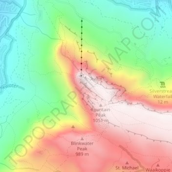
Name: Table Mountain topographic map, elevation, terrain.
Average elevation: 583 m
Minimum elevation: 130 m
Maximum elevation: 1,078 m
Make a donation
Other topographic maps
Click on a map to view its topography, its elevation and its terrain.
Make a donation
Make a donation
Make a donation
Castle of Good Hope
South Africa > Western Cape > City of Cape Town > Cape Town
Average elevation: 38 m