
Thank you for supporting this site ❤️
Make a donation
Make a donation
Yellowstone County topographic map
Click on the map to display elevation.
Thank you for supporting this site ❤️
Make a donation
Make a donation
About this map
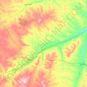
Name: Yellowstone County topographic map, elevation, terrain.
Location: Yellowstone County, Montana, United States (45.46131 -108.92566 46.49612 -107.46292)
Average elevation: 1,067 m
Minimum elevation: 831 m
Maximum elevation: 1,512 m
Thank you for supporting this site ❤️
Make a donation
Make a donation
Other topographic maps
Click on a map to view its topography, its elevation and its terrain.
Bozeman
United States > Montana > Gallatin County > Bozeman
Bozeman is located at an elevation of 4,820 feet (1,470 m). The Bridger Mountains are to the north-northeast, the Tobacco Root Mountains to the west-south-west, the Big Belt Mountains and Horseshoe Hills to the northwest, the Hyalite Peaks of the northern Gallatin Range to the south and the Spanish Peaks of…
Average elevation: 1,679 m