
Thank you for supporting this site ❤️
Make a donation
Make a donation
Forest Creek topographic map
Click on the map to display elevation.
Thank you for supporting this site ❤️
Make a donation
Make a donation
About this map
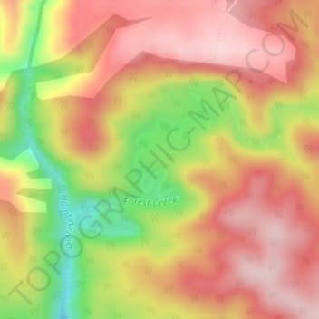
Name: Forest Creek topographic map, elevation, terrain.
Average elevation: 309 m
Minimum elevation: 139 m
Maximum elevation: 418 m
Thank you for supporting this site ❤️
Make a donation
Make a donation
Other topographic maps
Click on a map to view its topography, its elevation and its terrain.
Noetzie
South Africa > Western Cape > Garden Route District Municipality > Knysna Local Municipality
Average elevation: 72 m