
Ogden topographic map
Interactive map
Click on the map to display elevation.
About this map
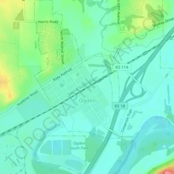
Name: Ogden topographic map, elevation, terrain.
Location: Ogden, Riley County, Kansas, 66517, United States (39.09897 -96.71736 39.12766 -96.68489)
Average elevation: 327 m
Minimum elevation: 308 m
Maximum elevation: 384 m
Other topographic maps
Click on a map to view its topography, its elevation and its terrain.
Zeandale
United States > Kansas > Riley County
Zeandale, Riley County, Kansas, United States
Average elevation: 314 m
Manhattan
United States > Kansas > Riley County > Manhattan
Manhattan, Riley County, Kansas, 66502-6322, United States
Average elevation: 365 m
Tuttle Creek Lake
United States > Kansas > Riley County
Tuttle Creek Lake, Riley County, Kansas, United States
Average elevation: 383 m
Manhattan
United States > Kansas > Riley County
Manhattan, Riley County, Kansas, United States
Average elevation: 344 m