
Thank you for supporting this site ❤️
Make a donation
Make a donation
Trisul I topographic map
Click on the map to display elevation.
Thank you for supporting this site ❤️
Make a donation
Make a donation
About this map
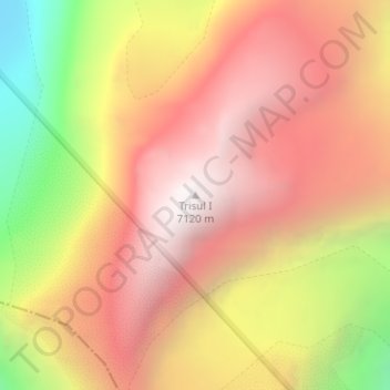
Name: Trisul I topographic map, elevation, terrain.
Location: Trisul I, Joshimath Tehsil, Chamoli, Uttarakhand, India (30.31311 79.77760 30.31321 79.77770)
Average elevation: 6,343 m
Minimum elevation: 5,172 m
Maximum elevation: 7,104 m
Thank you for supporting this site ❤️
Make a donation
Make a donation
Other topographic maps
Click on a map to view its topography, its elevation and its terrain.
Valley of Flowers National Park
India > Uttarakhand > Joshimath Tehsil > Ghangaria
Average elevation: 4,606 m
Thank you for supporting this site ❤️
Make a donation
Make a donation