
Thank you for supporting this site ❤️
Make a donation
Make a donation
Meise topographic map
Click on the map to display elevation.
Thank you for supporting this site ❤️
Make a donation
Make a donation
About this map
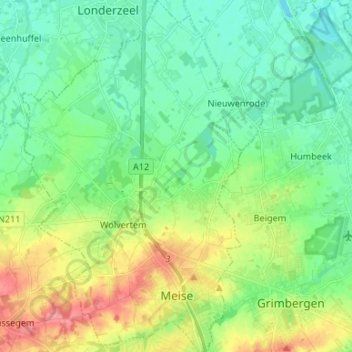
Name: Meise topographic map, elevation, terrain.
Location: Meise, Halle-Vilvoorde, Flemish Brabant, Flanders, Belgium (50.92073 4.27046 51.00438 4.35355)
Average elevation: 28 m
Minimum elevation: 2 m
Maximum elevation: 81 m
Thank you for supporting this site ❤️
Make a donation
Make a donation
Other topographic maps
Click on a map to view its topography, its elevation and its terrain.
Thank you for supporting this site ❤️
Make a donation
Make a donation
La Fresnaye
Belgium > Flemish Brabant > Halle-Vilvoorde > Buizingen > Ziekendries
Average elevation: 72 m
Lac de Genval - Meer van Genval
Belgium > Flemish Brabant > Halle-Vilvoorde > Overijse > Genval
Average elevation: 80 m
Thank you for supporting this site ❤️
Make a donation
Make a donation
Thank you for supporting this site ❤️
Make a donation
Make a donation
Thank you for supporting this site ❤️
Make a donation
Make a donation