
Thank you for supporting this site ❤️
Make a donation
Make a donation
Raaswater topographic map
Click on the map to display elevation.
Thank you for supporting this site ❤️
Make a donation
Make a donation
About this map
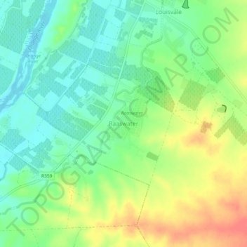
Name: Raaswater topographic map, elevation, terrain.
Average elevation: 792 m
Minimum elevation: 768 m
Maximum elevation: 826 m
Thank you for supporting this site ❤️
Make a donation
Make a donation
Other topographic maps
Click on a map to view its topography, its elevation and its terrain.
Eensaamheid Pan
South Africa > Northern Cape > ZF Mgcawu District Municipality > ǁKhara Hais Local Municipality
Average elevation: 848 m