
Thank you for supporting this site ❤️
Make a donation
Make a donation
Big Bend topographic map
Click on the map to display elevation.
Thank you for supporting this site ❤️
Make a donation
Make a donation
About this map
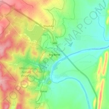
Name: Big Bend topographic map, elevation, terrain.
Location: Big Bend, Inkhundla Nkilongo, Lubombo, Eswatini (-26.83112 31.89836 -26.75112 31.97836)
Average elevation: 124 m
Minimum elevation: 70 m
Maximum elevation: 205 m
Thank you for supporting this site ❤️
Make a donation
Make a donation