
Thank you for supporting this site ❤️
Make a donation
Make a donation
Bric Tumela topographic map
Click on the map to display elevation.
Thank you for supporting this site ❤️
Make a donation
Make a donation
About this map
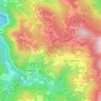
Name: Bric Tumela topographic map, elevation, terrain.
Location: Bric Tumela, Urbe, Savona, Liguria, 17048, Italy (44.47135 8.61642 44.47145 8.61652)
Average elevation: 781 m
Minimum elevation: 555 m
Maximum elevation: 981 m
Thank you for supporting this site ❤️
Make a donation
Make a donation