
Eastern West Khasi Hills District topographic map
Interactive map
Click on the map to display elevation.
About this map
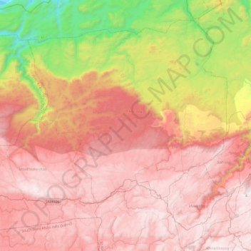
Name: Eastern West Khasi Hills District topographic map, elevation, terrain.
Location: Eastern West Khasi Hills District, Meghalaya, 793120, India (25.46964 91.34291 25.82786 91.81415)
Average elevation: 1,176 m
Minimum elevation: 59 m
Maximum elevation: 1,952 m
The Mawthadraishan Range runs east to west through the district. The highest elevation in the district is Mawthadraishan Peak at 1,924.5 metres (6,314 ft) above sea level, located approximately midway between the towns of Nongstoin and Mairang. Another notable elevation in the district is Kyllang Rock, a large granitic dome located 9 kilometres (5.6 mi) northwest of Mairang at 1,774 metres (5,820 ft) above sea level. This rock is personified as a man in various Khasi legends: one says that he is married to Thadlaskein Lake near Jowai, and another describes his battles with Symper Rock to the south near Mawkyrwat.
Other topographic maps
Click on a map to view its topography, its elevation and its terrain.
Khasi Hills
India > Meghalaya > Mawshynrut
Khasi Hills, Mawshynrut, West Khasi Hills District, Meghalaya, India
Average elevation: 349 m