
Make a donation
Flagstaff topographic map
Click on the map to display elevation.
Make a donation
Flagstaff
Flagstaff is the county seat of Coconino County. According to the United States Census Bureau, the city has a total area of 63.9 square miles (165.5 km2), of which only 0.03 square miles (0.08 km2) (0.08%) is water. Flagstaff lies at approximately 7,000 feet (2,130 m) elevation, and is surrounded by the largest contiguous ponderosa pine forest in North America. It is in a mountainous area, and lies along the Rio de Flag watercourse. It is about 130 miles (210 km) north of the State capital, Phoenix.
Make a donation
About this map
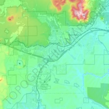
Name: Flagstaff topographic map, elevation, terrain.
Location: Flagstaff, Coconino County, Arizona, United States (35.12240 -111.70894 35.24010 -111.50678)
Average elevation: 2,176 m
Minimum elevation: 2,008 m
Maximum elevation: 2,830 m
Make a donation
Other topographic maps
Click on a map to view its topography, its elevation and its terrain.