
Staffordshire Moorlands topographic map
Interactive map
Click on the map to display elevation.
About this map
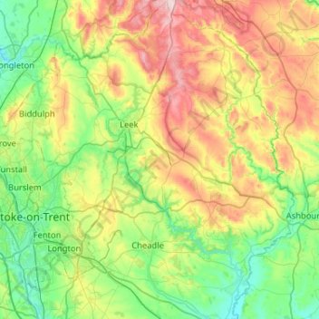
Name: Staffordshire Moorlands topographic map, elevation, terrain.
Average elevation: 227 m
Minimum elevation: 75 m
Maximum elevation: 548 m
Other topographic maps
Click on a map to view its topography, its elevation and its terrain.
Thorncliffe
United Kingdom > England > Staffordshire > Staffordshire Moorlands
Thorncliffe, Staffordshire Moorlands, Staffordshire, England, ST13 7LP, United Kingdom
Average elevation: 312 m
Derrington
United Kingdom > England > Staffordshire > Stafford
Derrington, Stafford, Staffordshire, England, ST18 9NJ, United Kingdom
Average elevation: 93 m
Lichfield
United Kingdom > England > Staffordshire > Lichfield
Lichfield, Staffordshire, West Midlands, England, United Kingdom
Average elevation: 91 m