
Sillein topographic map
Interactive map
Click on the map to display elevation.
About this map
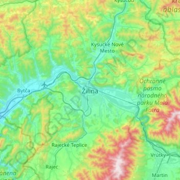
Name: Sillein topographic map, elevation, terrain.
Average elevation: 569 m
Minimum elevation: 292 m
Maximum elevation: 1,478 m
Other topographic maps
Click on a map to view its topography, its elevation and its terrain.
Strečno
Slowakei > Silleiner Landschaftsverband > Sillein > Strečno
Strečno, Sillein, Silleiner Landschaftsverband, Mittelslowakei, 013 24, Slowakei
Average elevation: 411 m