
South Hero topographic map
Interactive map
Click on the map to display elevation.
About this map
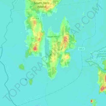
Name: South Hero topographic map, elevation, terrain.
Location: South Hero, Grand Isle County, Vermont, 05486, United States (44.56445 -73.39023 44.68826 -73.22841)
Average elevation: 33 m
Minimum elevation: 25 m
Maximum elevation: 92 m
Other topographic maps
Click on a map to view its topography, its elevation and its terrain.
Grand Isle
United States > Vermont > Grand Isle County
Grand Isle, Grand Isle County, Vermont, 05458, United States
Average elevation: 36 m
Isle La Motte
United States > Vermont > Grand Isle County
Isle La Motte, Grand Isle County, Vermont, 05463, United States
Average elevation: 35 m
North Hero
United States > Vermont > Grand Isle County
North Hero, Grand Isle County, Vermont, 05474, United States
Average elevation: 32 m
Alburgh
United States > Vermont > Grand Isle County
Alburgh, Grand Isle County, Vermont, 05440, United States
Average elevation: 35 m