
Thank you for supporting this site ❤️
Make a donation
Make a donation
eChibini Tarn topographic map
Click on the map to display elevation.
Thank you for supporting this site ❤️
Make a donation
Make a donation
About this map
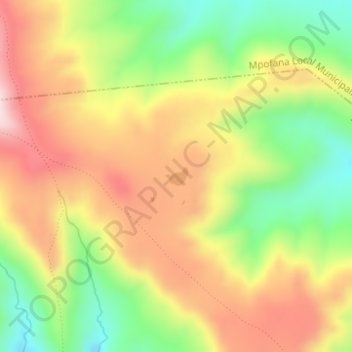
Name: eChibini Tarn topographic map, elevation, terrain.
Average elevation: 2,294 m
Minimum elevation: 2,121 m
Maximum elevation: 2,462 m
Thank you for supporting this site ❤️
Make a donation
Make a donation
Other topographic maps
Click on a map to view its topography, its elevation and its terrain.
Mohlesi (Umkomass)
South Africa > KwaZulu-Natal > uMgungundlovu District Municipality > Impendle Local Municipality
Average elevation: 3,113 m
Mohlesi (Umkomass)
South Africa > KwaZulu-Natal > uMgungundlovu District Municipality > Impendle Local Municipality
Average elevation: 3,113 m