
Thank you for supporting this site ❤️
Make a donation
Make a donation
Handren Hill topographic map
Click on the map to display elevation.
Thank you for supporting this site ❤️
Make a donation
Make a donation
About this map
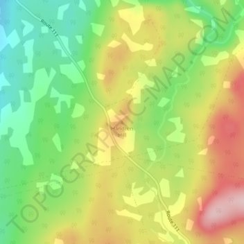
Name: Handren Hill topographic map, elevation, terrain.
Average elevation: 180 m
Minimum elevation: 77 m
Maximum elevation: 298 m
Thank you for supporting this site ❤️
Make a donation
Make a donation
Other topographic maps
Click on a map to view its topography, its elevation and its terrain.
Bains Corner
Canada > New Brunswick > Saint John County > Village of Fundy-St. Martins
Average elevation: 88 m