
Oerle topographic map
Interactive map
Click on the map to display elevation.
About this map
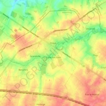
Name: Oerle topographic map, elevation, terrain.
Location: Oerle, Borgworm, Luik, Wallonië, 4360, België (50.69941 5.30393 50.74797 5.39447)
Average elevation: 115 m
Minimum elevation: 78 m
Maximum elevation: 142 m
Other topographic maps
Click on a map to view its topography, its elevation and its terrain.
Ville-en-Hesbaye
België > Luik > Borgworm > Ville-en-Hesbaye
Ville-en-Hesbaye, Braives, Borgworm, Luik, Wallonië, 4260, België
Average elevation: 146 m