
St. Wendel topographic map
Interactive map
Click on the map to display elevation.
About this map
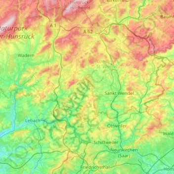
Name: St. Wendel topographic map, elevation, terrain.
Location: St. Wendel, Landkreis St. Wendel, Saarland, Duitsland (49.31815 6.78535 49.63943 7.30920)
Average elevation: 365 m
Minimum elevation: 195 m
Maximum elevation: 701 m
Other topographic maps
Click on a map to view its topography, its elevation and its terrain.
Bostalsee
Duitsland > Saarland > Landkreis St. Wendel > Nohfelden
Bostalsee, Gonnesweiler, Nohfelden, Landkreis St. Wendel, Saarland, Duitsland
Average elevation: 412 m
Nohfelden
Duitsland > Saarland > Landkreis St. Wendel
Nohfelden, Landkreis St. Wendel, Saarland, 66625, Duitsland
Average elevation: 432 m