
Dorfbach topographic map
Interactive map
Click on the map to display elevation.
About this map
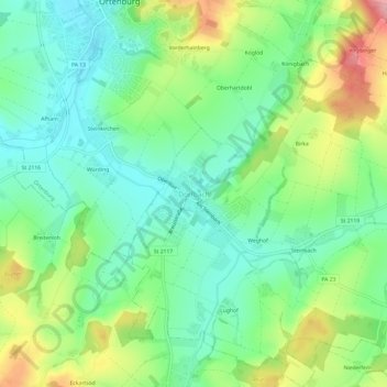
Name: Dorfbach topographic map, elevation, terrain.
Average elevation: 386 m
Minimum elevation: 338 m
Maximum elevation: 476 m
Other topographic maps
Click on a map to view its topography, its elevation and its terrain.
Schloss Ortenburg
Deutschland > Bayern > Landkreis Passau > Ortenburg > Söldenau > Vorderschloß
Schloss Ortenburg, 1, Vorderschloss, Vorderschloß, Söldenau, Ortenburg, Landkreis Passau, Bayern, 94496, Deutschland
Average elevation: 387 m
Vorderhainberg
Deutschland > Bayern > Landkreis Passau > Ortenburg
Vorderhainberg, Ortenburg, Landkreis Passau, Bayern, 94496, Deutschland
Average elevation: 387 m
Unteriglbach
Deutschland > Bayern > Landkreis Passau > Ortenburg
Unteriglbach, Ortenburg, Landkreis Passau, Bayern, 94496, Deutschland
Average elevation: 373 m
Oberiglbach
Deutschland > Bayern > Landkreis Passau > Ortenburg > Oberiglbach
Oberiglbach, Ortenburg, Landkreis Passau, Bayern, Deutschland
Average elevation: 389 m