
Make a donation
Sitapur topographic map
Click on the map to display elevation.
Make a donation
Sitapur
Sitapur is located at 27.57°N 80.68°E. It test has an average elevation of 138 meters (452 feet). It is located in the Gangetic Plain, with elevations ranging from 150 m above sea level in the north-west to 100 m in the south-east. It is intersected by numerous streams and ravines and contains many shallow ponds and natural reservoirs, which overflow during the rainy seasons, but become dry, in some places, in the hot season. Except in the eastern portion, which lies in the doabs between the Kewani and the Chauka, and the Ghaghra and the Chauka rivers, the soil is semi arid. Even this moist tract is interspersed with patches of land covered with saline efflorescence called reh.
Make a donation
About this map
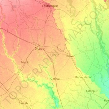
Name: Sitapur topographic map, elevation, terrain.
Location: Sitapur, Uttar Pradesh, India (27.10146 80.29944 27.90762 81.41530)
Average elevation: 131 m
Minimum elevation: 108 m
Maximum elevation: 158 m
Make a donation
Other topographic maps
Click on a map to view its topography, its elevation and its terrain.
Varanasi
India > Uttar Pradesh > Sadar
Varanasi is located at an elevation of 80.71 metres (264.8 ft) in the centre of the Ganges valley of North India, in the Eastern part of the state of Uttar Pradesh, along the left crescent-shaped bank of the Ganges, averaging between 15 metres (50 ft) and 21 metres (70 ft) above the river. The city is the…
Average elevation: 77 m
Prayagraj
India > Uttar Pradesh > Prayagraj
Prayagraj's elevation is over 90 m (295 ft) above sea level. The old part of the city, at the south of Prayagraj Junction railway station, consists of neighbourhoods like Chowk, Johnstongunj, Dariyabad, Khuldabad and many more. In the north of the Railway Station, the new city consists of neighbourhoods like…
Average elevation: 91 m
Lucknow
India > Uttar Pradesh > Lucknow
Lucknow stands at an elevation of approximately 123 metres (404 ft) above sea level. The city had an area of 402 km2 (155 square miles) until December 2019, when 88 villages were added to the municipal limits and the area increased to 631 km2 (244 square miles).
Average elevation: 120 m