
Thank you for supporting this site ❤️
Make a donation
Make a donation
Allen Heights topographic map
Click on the map to display elevation.
Thank you for supporting this site ❤️
Make a donation
Make a donation
About this map
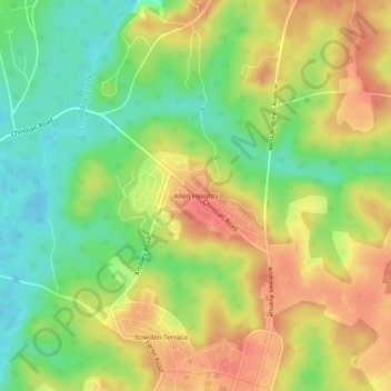
Name: Allen Heights topographic map, elevation, terrain.
Location: Allen Heights, Dale County, Alabama, 36362, United States (31.34323 -85.73383 31.38323 -85.69383)
Average elevation: 89 m
Minimum elevation: 53 m
Maximum elevation: 124 m
Thank you for supporting this site ❤️
Make a donation
Make a donation
Other topographic maps
Click on a map to view its topography, its elevation and its terrain.
Thank you for supporting this site ❤️
Make a donation
Make a donation
Thank you for supporting this site ❤️
Make a donation
Make a donation