
Cape Town Ward 74 topographic map
Interactive map
Click on the map to display elevation.
About this map
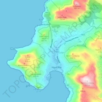
Name: Cape Town Ward 74 topographic map, elevation, terrain.
Average elevation: 181 m
Minimum elevation: 0 m
Maximum elevation: 921 m
Other topographic maps
Click on a map to view its topography, its elevation and its terrain.
Ken Heights Private Nature Reserve
RSA > Western Cape > Hout Bay
Ken Heights Private Nature Reserve, Eagle Avenue, Cape Town Ward 74, Hout Bay, City of Cape Town, Western Cape, 7806, RSA
Average elevation: 251 m