
Nandrin topographic map
Interactive map
Click on the map to display elevation.
About this map
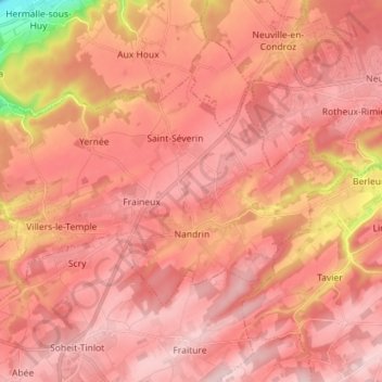
Name: Nandrin topographic map, elevation, terrain.
Location: Nandrin, Huy, Liège, Wallonia, 4550, Belgium (50.48846 5.33488 50.54389 5.47694)
Average elevation: 228 m
Minimum elevation: 61 m
Maximum elevation: 298 m
Other topographic maps
Click on a map to view its topography, its elevation and its terrain.
Grand-Marchin
Belgium > Liège > Huy > Marchin
Grand-Marchin, Marchin, Huy, Liège, Wallonia, 4570, Belgium
Average elevation: 225 m
Trou Dubois
Belgium > Liège > Huy > Wanze > Moha > Le Taillis
Trou Dubois, Rue du Madot, Les communes, Le Taillis, Moha, Wanze, Huy, Liège, Wallonia, 4520, Belgium
Average elevation: 130 m