Sandown topographic map
Interactive map
Click on the map to display elevation.
About this map
![Sandown topographic map, elevation, terrain](/pub/maps/relation/12cz/8llfnh/thumbnail.jpg)
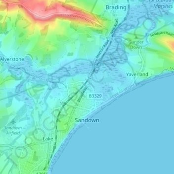
Name: Sandown topographic map, elevation, terrain.
Location: Sandown, Isle of Wight, England, United Kingdom (50.64936 -1.17610 50.67318 -1.10774)
Average elevation: 18 m
Minimum elevation: -2 m
Maximum elevation: 129 m
Other topographic maps
Click on a map to view its topography, its elevation and its terrain.
![Newport topographic map, elevation, terrain](/pub/maps/node/9n4s/871z1h/icon.jpg)
Newport
United Kingdom > England > Isle of Wight
Newport, Isle of Wight, England, PO30 5HD, United Kingdom
Average elevation: 45 m
![Shanklin topographic map, elevation, terrain](/pub/maps/relation/4r1h/pldrmt/icon.jpg)
Shanklin
United Kingdom > England > Isle of Wight > Shanklin
Shanklin, Isle of Wight, South East England, England, United Kingdom
Average elevation: 51 m
![Winford topographic map, elevation, terrain](/pub/maps/node/9n18/98l7s8/icon.jpg)
Winford
United Kingdom > England > Isle of Wight > Winford
Winford, Newchurch, Isle of Wight, South East England, England, PO36 0PD, United Kingdom
Average elevation: 30 m