
Thank you for supporting this site ❤️
Make a donation
Make a donation
Willowvale topographic map
Click on the map to display elevation.
Thank you for supporting this site ❤️
Make a donation
Make a donation
About this map
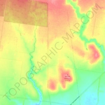
Name: Willowvale topographic map, elevation, terrain.
Location: Willowvale, Golden Plains Shire, Victoria, 3360, Australia (-37.88206 143.44055 -37.79876 143.49051)
Average elevation: 237 m
Minimum elevation: 190 m
Maximum elevation: 279 m
Thank you for supporting this site ❤️
Make a donation
Make a donation
Other topographic maps
Click on a map to view its topography, its elevation and its terrain.