
Thank you for supporting this site ❤️
Make a donation
Make a donation
The Commons Field topographic map
Click on the map to display elevation.
Thank you for supporting this site ❤️
Make a donation
Make a donation
About this map
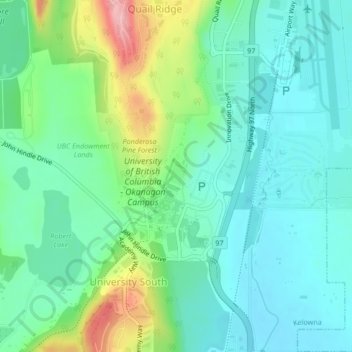
Name: The Commons Field topographic map, elevation, terrain.
Average elevation: 442 m
Minimum elevation: 400 m
Maximum elevation: 557 m
Thank you for supporting this site ❤️
Make a donation
Make a donation
Other topographic maps
Click on a map to view its topography, its elevation and its terrain.
Okanagan Lake
Canada > British Columbia > Regional District of Central Okanagan > Kelowna
Average elevation: 1,194 m
Pandosy
Canada > British Columbia > Regional District of Central Okanagan > Kelowna
Average elevation: 345 m
Abbott Street Conservation Area
Canada > British Columbia > Regional District of Central Okanagan > Kelowna > Pandosy
Average elevation: 345 m
Knox Mountain
Canada > British Columbia > Regional District of Central Okanagan > Kelowna
Average elevation: 430 m
Thank you for supporting this site ❤️
Make a donation
Make a donation
Knox Mountain
Canada > British Columbia > Regional District of Central Okanagan > Kelowna
Average elevation: 430 m