
Thank you for supporting this site ❤️
Make a donation
Make a donation
Lac du Der-Chantecoq topographic map
Click on the map to display elevation.
Thank you for supporting this site ❤️
Make a donation
Make a donation
About this map
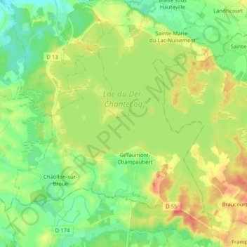
Name: Lac du Der-Chantecoq topographic map, elevation, terrain.
Average elevation: 133 m
Minimum elevation: 110 m
Maximum elevation: 166 m
Thank you for supporting this site ❤️
Make a donation
Make a donation
Other topographic maps
Click on a map to view its topography, its elevation and its terrain.
Blaise sous Hauteville
France > Grand Est > Marne > Sainte-Marie-du-Lac-Nuisement
Average elevation: 130 m