
Eppelborn topographic map
Interactive map
Click on the map to display elevation.
About this map
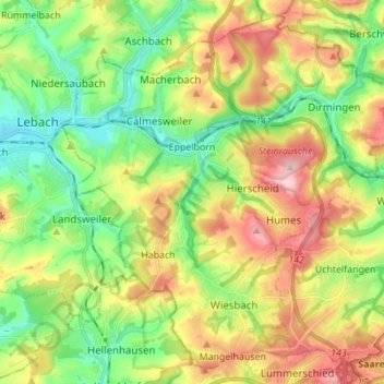
Name: Eppelborn topographic map, elevation, terrain.
Location: Eppelborn, Landkreis Neunkirchen, Saarland, 66571, Duitsland (49.35562 6.91750 49.43797 7.05500)
Average elevation: 297 m
Minimum elevation: 214 m
Maximum elevation: 418 m
Other topographic maps
Click on a map to view its topography, its elevation and its terrain.
Heiligenwald
Duitsland > Saarland > Landkreis Neunkirchen > Schiffweiler
Heiligenwald, Schiffweiler, Landkreis Neunkirchen, Saarland, Duitsland
Average elevation: 329 m