
Mount Lebanon topographic map
Interactive map
Click on the map to display elevation.
About this map
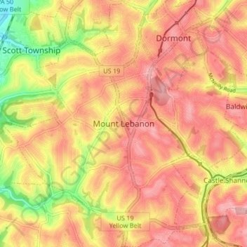
Name: Mount Lebanon topographic map, elevation, terrain.
Average elevation: 347 m
Minimum elevation: 267 m
Maximum elevation: 397 m
Other topographic maps
Click on a map to view its topography, its elevation and its terrain.
Allison Park
United States > Pennsylvania > Allegheny County > Hampton Township
Average elevation: 324 m
Observatory Hill
United States > Pennsylvania > Allegheny County > Pittsburgh
Average elevation: 319 m
Allegheny River Lock and Dam No. 2
United States > Pennsylvania > Allegheny County > O'Hara Township
Average elevation: 268 m
Stoneybrooke Woods
United States > Pennsylvania > Allegheny County > Cheswick
Average elevation: 283 m
Highland Park Reservoir No. 2
United States > Pennsylvania > Allegheny County > Pittsburgh
Average elevation: 275 m
Lovedale
United States > Pennsylvania > Allegheny County > Elizabeth Township
Average elevation: 298 m
Cochrans Mill
United States > Pennsylvania > Allegheny County > Jefferson Hills
Average elevation: 311 m
Neville Island
United States > Pennsylvania > Allegheny County > Neville Township
Average elevation: 289 m
Dorseyville
United States > Pennsylvania > Allegheny County > Indiana Township
Average elevation: 325 m
Glenwillard
United States > Pennsylvania > Allegheny County > Crescent Township > Glenwillard
Average elevation: 278 m
Carnot
United States > Pennsylvania > Allegheny County > Moon Township > Carnot
Average elevation: 336 m
Bakerstown
United States > Pennsylvania > Allegheny County > Richland Township
Average elevation: 356 m
Fairoaks
United States > Pennsylvania > Allegheny County > Leet Township > Fairoaks
Average elevation: 269 m
Clinton
United States > Pennsylvania > Allegheny County > Findlay Township > Clinton
Average elevation: 350 m
Coverdale
United States > Pennsylvania > Allegheny County > Bethel Park > Coverdale
Average elevation: 354 m