
Thank you for supporting this site ❤️
Make a donation
Make a donation
Waterval Boven topographic map
Click on the map to display elevation.
Thank you for supporting this site ❤️
Make a donation
Make a donation
About this map
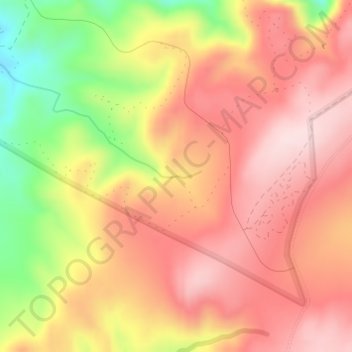
Name: Waterval Boven topographic map, elevation, terrain.
Average elevation: 986 m
Minimum elevation: 788 m
Maximum elevation: 1,104 m
Thank you for supporting this site ❤️
Make a donation
Make a donation
Other topographic maps
Click on a map to view its topography, its elevation and its terrain.
Mkuze Falls
South Africa > KwaZulu-Natal > Zululand District Municipality > uPhongolo Local Municipality
Average elevation: 347 m