
Make a donation
Los Aquijes topographic map
Click on the map to display elevation.
Make a donation
About this map
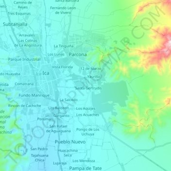
Name: Los Aquijes topographic map, elevation, terrain.
Location: Los Aquijes, Ica, Perú (-14.11776 -75.71909 -14.03351 -75.55643)
Average elevation: 501 m
Minimum elevation: 378 m
Maximum elevation: 1,302 m
Make a donation
Other topographic maps
Click on a map to view its topography, its elevation and its terrain.
Make a donation
Make a donation
Make a donation
Make a donation
Make a donation
Make a donation
Make a donation
Make a donation
Make a donation
Make a donation
Lineas de Nasca
Perú > Ica > San Miguel de la Pascana
Las pampas de Jumana están situadas a una altitud de 330 m s. n. m. y mantienen una temperatura media anual de 25 grados centígrados en una de las zonas más secas del planeta, lo que ayuda a conservar los dibujos. El aire caliente actúa como un "colchón" que impide que las líneas se borren porque obliga…
Average elevation: 456 m
Make a donation
Make a donation
Make a donation
Make a donation
Make a donation
Make a donation
Make a donation
Playa Lurinchincha "El Manantial"
Perú > Ica > Chincha Baja > Lurinchincha > La Playa
Average elevation: 5 m
Make a donation
Make a donation
Make a donation
Make a donation
Make a donation
Make a donation
Fundo Llancay Grande
Perú > Ica > San Jose de Los Molinos > Cerro Salvador > Fundo Llancay Grande
Average elevation: 536 m
Make a donation
Make a donation