
Municipality of Jasper topographic map
Interactive map
Click on the map to display elevation.
About this map
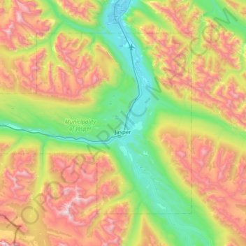
Name: Municipality of Jasper topographic map, elevation, terrain.
Average elevation: 1,789 m
Minimum elevation: 997 m
Maximum elevation: 3,110 m
Jasper liegt im Jasper-Nationalpark nahe der Grenze zwischen den Provinzen British Columbia und Alberta in einer Höhe von 1062 m. Die Gemeinde ist vom Westen und vom Osten her über den Yellowhead Highway (Alberta Highway 16) und von Süden her über den Icefields Parkway (Alberta Highway 93) zu erreichen.
Other topographic maps
Click on a map to view its topography, its elevation and its terrain.
Toronto Peak
Kanada > Alberta > Division No. 15
Toronto Peak, Division No. 15, Alberta, Kanada
Average elevation: 2,423 m