
Effingham topographic map
Interactive map
Click on the map to display elevation.
About this map
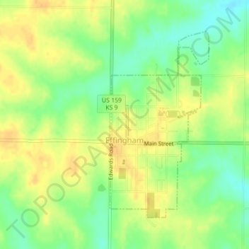
Name: Effingham topographic map, elevation, terrain.
Location: Effingham, Atchison County, Kansas, United States (39.51381 -95.40286 39.53403 -95.38894)
Average elevation: 340 m
Minimum elevation: 322 m
Maximum elevation: 353 m
Other topographic maps
Click on a map to view its topography, its elevation and its terrain.
Huron
United States > Kansas > Atchison County
Huron, Atchison County, Kansas, United States
Average elevation: 349 m
Cummings
United States > Kansas > Atchison County
Cummings, Center Township, Atchison County, Kansas, 66016, United States
Average elevation: 316 m
Muscotah
United States > Kansas > Atchison County
Muscotah, Atchison County, Kansas, 66058, United States
Average elevation: 304 m
Lancaster
United States > Kansas > Atchison County
Lancaster, Atchison County, Kansas, United States
Average elevation: 344 m
Shannon
United States > Kansas > Atchison County
Shannon, Lancaster Township, Atchison County, Kansas, United States
Average elevation: 330 m
Atchison
United States > Kansas > Atchison County
Atchison, Atchison County, Kansas, United States
Average elevation: 274 m
Mount Pleasant Township
United States > Kansas > Atchison County
Mount Pleasant Township, Atchison County, Kansas, United States
Average elevation: 311 m