
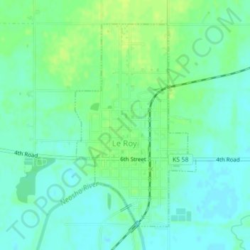
LeRoy topographic map
Interactive map
Click on the map to display elevation.
About this map
Name: LeRoy topographic map, elevation, terrain.
Location: LeRoy, Coffey County, Kansas, 66857, United States (38.07489 -95.64123 38.09677 -95.62460)
Average elevation: 306 m
Minimum elevation: 299 m
Maximum elevation: 313 m
Other topographic maps
Click on a map to view its topography, its elevation and its terrain.
Gridley
United States > Kansas > Coffey County
Gridley, Coffey County, Kansas, United States
Average elevation: 350 m
Lebo
United States > Kansas > Coffey County
Lebo, Coffey County, Kansas, United States
Average elevation: 351 m
New Strawn
United States > Kansas > Coffey County
New Strawn, Coffey County, Kansas, United States
Average elevation: 336 m
Waverly
United States > Kansas > Coffey County
Waverly, Coffey County, Kansas, United States
Average elevation: 344 m
Burlington
United States > Kansas > Coffey County
Burlington, Coffey County, Kansas, United States
Average elevation: 315 m