
Windham topographic map
Interactive map
Click on the map to display elevation.
About this map
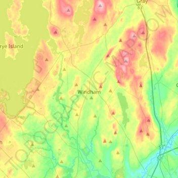
Name: Windham topographic map, elevation, terrain.
Location: Windham, Cumberland County, Maine, 04062, United States (43.69741 -70.48674 43.88658 -70.32438)
Average elevation: 77 m
Minimum elevation: 4 m
Maximum elevation: 183 m
Other topographic maps
Click on a map to view its topography, its elevation and its terrain.
Casco
United States > Maine > Cumberland County
Casco, Cumberland County, Maine, 04015, United States
Average elevation: 122 m
Sebago
United States > Maine > Cumberland County
Sebago, Cumberland County, Maine, 04029, United States
Average elevation: 160 m
Bradbury Mountain
United States > Maine > Cumberland County > Pownal
Bradbury Mountain, Pownal, Cumberland County, Maine, 04069, United States
Average elevation: 71 m
Gray
United States > Maine > Cumberland County
Gray, Cumberland County, Maine, 04039, United States
Average elevation: 92 m
Sebago Lake
United States > Maine > Cumberland County > Standish
Sebago Lake, Standish, Cumberland County, Maine, 04084, United States
Average elevation: 102 m
North Yarmouth
United States > Maine > Cumberland County > North Yarmouth
North Yarmouth, Cumberland County, Maine, 04097, United States
Average elevation: 59 m
Pownal
United States > Maine > Cumberland County
Pownal, Cumberland County, Maine, 04069, United States
Average elevation: 54 m
Harpswell
United States > Maine > Cumberland County
Harpswell, Cumberland County, Maine, 04079, United States
Average elevation: 5 m
Standish
United States > Maine > Cumberland County
Standish, Cumberland County, Maine, 04084, United States
Average elevation: 88 m
Portland
United States > Maine > Cumberland County
Portland, Cumberland County, Maine, United States
Average elevation: 16 m
Scarborough
United States > Maine > Cumberland County
Scarborough, Cumberland County, Maine, 04074, United States
Average elevation: 17 m
South Portland
United States > Maine > Cumberland County > South Portland
South Portland, Cumberland County, Maine, 04106, United States
Average elevation: 9 m
Cumberland County
United States > Maine > Cumberland County
Cumberland County, Maine, United States
Average elevation: 85 m