
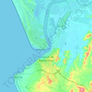
Sanlúcar de Barrameda topographic map
Interactive map
Click on the map to display elevation.
About this map
Name: Sanlúcar de Barrameda topographic map, elevation, terrain.
Average elevation: 11 m
Minimum elevation: -3 m
Maximum elevation: 95 m
Sanlúcar de Barrameda borders the municipalities of Trebujena, Jerez de la Frontera, Rota, Puerto de Santa María, and Chipiona. Its topography is shown in the MTN50 sheet (scale 1:50,000) No. 1047 of the National Topographic Map.
Other topographic maps
Click on a map to view its topography, its elevation and its terrain.
La Cañada
Spain > Andalusia > Northwest Coast > Trebujena
La Cañada, Trebujena, Northwest Coast, Cádiz, Andalusia, 11560, Spain
Average elevation: 40 m
Rota
Spain > Andalusia > Northwest Coast
Rota, Northwest Coast, Cádiz, Andalusia, 11520, Spain
Average elevation: 18 m