
Fort Dauphin topographic map
Interactive map
Click on the map to display elevation.
About this map
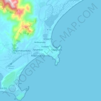
Name: Fort Dauphin topographic map, elevation, terrain.
Average elevation: 35 m
Minimum elevation: -3 m
Maximum elevation: 653 m
Other topographic maps
Click on a map to view its topography, its elevation and its terrain.
Plage Libanona
Madagascar > Anosy > Fort Dauphin
Plage Libanona, Bazarikely, Fort Dauphin, District de Tôlanaro, Anosy, Province de Tuléar, Madagascar
Average elevation: 5 m