
Thank you for supporting this site ❤️
Make a donation
Make a donation
Boothbay Harbor topographic map
Click on the map to display elevation.
Thank you for supporting this site ❤️
Make a donation
Make a donation
About this map
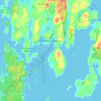
Name: Boothbay Harbor topographic map, elevation, terrain.
Location: Boothbay Harbor, Lincoln County, Maine, United States (43.81733 -69.69293 43.87310 -69.59971)
Average elevation: 14 m
Minimum elevation: -3 m
Maximum elevation: 69 m
Thank you for supporting this site ❤️
Make a donation
Make a donation
Other topographic maps
Click on a map to view its topography, its elevation and its terrain.