
Thank you for supporting this site ❤️
Make a donation
Make a donation
Highlands County topographic map
Click on the map to display elevation.
Thank you for supporting this site ❤️
Make a donation
Make a donation
About this map
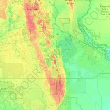
Name: Highlands County topographic map, elevation, terrain.
Location: Highlands County, Florida, United States (27.03229 -81.56409 27.64665 -80.94181)
Average elevation: 22 m
Minimum elevation: 3 m
Maximum elevation: 62 m
Thank you for supporting this site ❤️
Make a donation
Make a donation
Other topographic maps
Click on a map to view its topography, its elevation and its terrain.
Thank you for supporting this site ❤️
Make a donation
Make a donation
Bass Bay
United States > Florida > Charlotte County > Punta Gorda > Punta Gorda Isles
Average elevation: 2 m