
Make a donation
Poteau topographic map
Click on the map to display elevation.
Make a donation
Poteau
The city is located in the valley below Cavanal Hill, dubbed the "World's Highest Hill" with a signed elevation of 1,999 feet (609 m). The location was a subject of extensive coal mining in the first half of the 20th Century, and a railway, eventually called the Poteau and Cavanal Mountain Railroad, served the mines. The summit elevation of the hill is 2,385 feet (727 m) above sea level, while the hill rises 1,960 feet (600 m) above the Poteau River on the east side of Poteau. The Poteau River is the only river in Oklahoma that flows north. It flows into Arkansas where it meets the Arkansas River at Belle Point in Fort Smith.
Make a donation
About this map
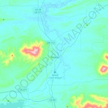
Name: Poteau topographic map, elevation, terrain.
Location: Poteau, LeFlore County, Oklahoma, 74953, United States (34.92772 -94.73447 35.20218 -94.57137)
Average elevation: 189 m
Minimum elevation: 125 m
Maximum elevation: 770 m
Make a donation
Other topographic maps
Click on a map to view its topography, its elevation and its terrain.