
Make a donation
Wells topographic map
Click on the map to display elevation.
Make a donation
Wells
According to the United States Census Bureau, the town has a total area of 73.61 square miles (190.65 km2), of which, 57.55 square miles (149.05 km2) of it is land and 16.06 square miles (41.60 km2) is water. Wells is drained by the Webhannet River. The highest point in town is an unnamed hill located a half mile south of the intersection of State Route 9 and Bragdon Road, which is 360 feet (110 m) above sea level. The lowest elevation is sea level, along the coastline with the Atlantic Ocean.
Make a donation
About this map
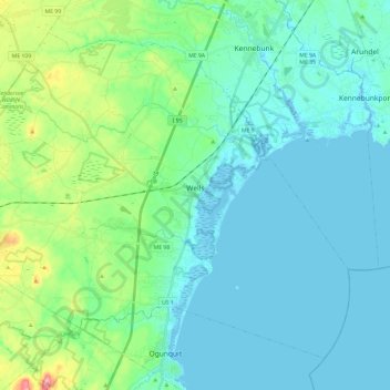
Name: Wells topographic map, elevation, terrain.
Location: Wells, York County, Maine, 04090, United States (43.24671 -70.72419 43.39123 -70.48721)
Average elevation: 28 m
Minimum elevation: -6 m
Maximum elevation: 153 m
Make a donation