
Scituate Center topographic map
Interactive map
Click on the map to display elevation.
About this map
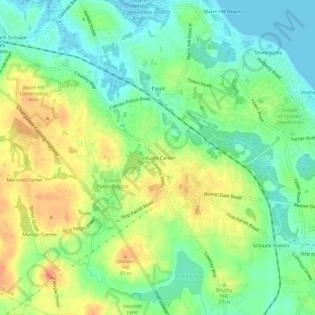
Name: Scituate Center topographic map, elevation, terrain.
Average elevation: 20 m
Minimum elevation: -2 m
Maximum elevation: 47 m
Other topographic maps
Click on a map to view its topography, its elevation and its terrain.
Minot
United States > Massachusetts > Plymouth County > Scituate
Minot, Scituate, Plymouth County, Massachusetts, 02060, United States
Average elevation: 2 m
Egypt
United States > Massachusetts > Plymouth County > Scituate
Egypt, Scituate, Plymouth County, Massachusetts, 02066, United States
Average elevation: 16 m