
Bloomington topographic map
Interactive map
Click on the map to display elevation.
About this map
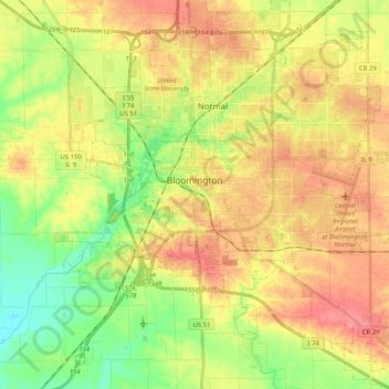
Name: Bloomington topographic map, elevation, terrain.
Location: Bloomington, McLean County, Illinois, United States (40.42944 -89.06772 40.51835 -88.86354)
Average elevation: 246 m
Minimum elevation: 210 m
Maximum elevation: 280 m
Bloomington is located at 40°29′03″N 88°59′37″W. The city is at an elevation of 797 feet (243 m) above sea level. According to the 2010 census, Bloomington has an area of 27.229 square miles (70.52 km2), of which 27.22 square miles (70.50 km2) (99.97%) is land and 0.009 square miles (0.02 km2) (0.03%) is water.