
Thank you for supporting this site ❤️
Make a donation
Make a donation
Harrison topographic map
Click on the map to display elevation.
Thank you for supporting this site ❤️
Make a donation
Make a donation
About this map
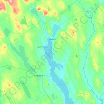
Name: Harrison topographic map, elevation, terrain.
Location: Harrison, Cumberland County, Maine, 04040, United States (44.01049 -70.69958 44.17105 -70.58723)
Average elevation: 157 m
Minimum elevation: 75 m
Maximum elevation: 408 m
Thank you for supporting this site ❤️
Make a donation
Make a donation
Other topographic maps
Click on a map to view its topography, its elevation and its terrain.
Cliff Island
United States > Maine > Cumberland County > Portland > Cliff Island
Average elevation: 1 m
Thank you for supporting this site ❤️
Make a donation
Make a donation
Thank you for supporting this site ❤️
Make a donation
Make a donation