
Pontianak topographic map
Interactive map
Click on the map to display elevation.
About this map
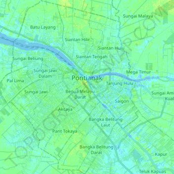
Name: Pontianak topographic map, elevation, terrain.
Location: Pontianak, Kalimantan occidental, Kalimantan, Indonésie (-0.09819 109.27417 0.03812 109.38535)
Average elevation: 4 m
Minimum elevation: -7 m
Maximum elevation: 9 m
Other topographic maps
Click on a map to view its topography, its elevation and its terrain.
Suti Semarang
Indonésie > Kalimantan occidental > Bengkayang
Suti Semarang, Bengkayang, Kalimantan occidental, Indonésie
Average elevation: 101 m
Bangka Belitung Laut
Indonésie > Kalimantan occidental > Pontianak
Bangka Belitung Laut, Pontianak Tenggara, Pontianak, Kalimantan occidental, 78242, Indonésie
Average elevation: 3 m
Suti Semarang
Indonésie > Kalimantan occidental
Suti Semarang, Bengkayang, Kalimantan occidental, Indonésie
Average elevation: 378 m
Sanggau
Indonésie > Kalimantan occidental > Sanggau
Sanggau, Kalimantan occidental, Indonésie
Average elevation: 42 m
Jayawijaya
Indonésie > Kalimantan occidental
Jayawijaya, Kalimantan occidental, Indonésie
Average elevation: 5 m