Geolocate

Madonas novads topographic map

Interactive map

Click on the map to display elevation.

About this map

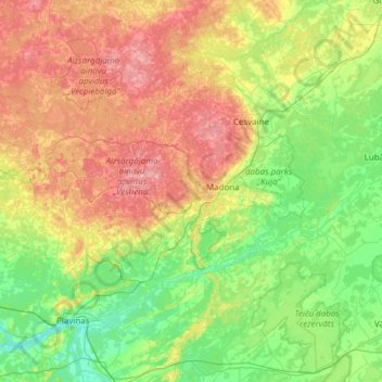
Name: Madonas novads topographic map, elevation, terrain.

Location: Madonas novads, Vidzeme, Latvia (56.58526 25.72506 57.10207 26.94358)

Average elevation: 141 m

Minimum elevation: 71 m

Maximum elevation: 304 m

Other topographic maps

Click on a map to view its topography, its elevation and its terrain.

Riga

Latvia > Vidzeme

Riga, Vidzeme, Latvia

Average elevation: 7 m

Vidzeme

Latvia > Vidzeme

Vidzeme, Latvia

Average elevation: 77 m

Gauja National Park

Latvia > Vidzeme

Gauja National Park, Slikts ceļš, Edernieki, Pārgaujas novads, Vidzeme, LV-4146, Latvia

Average elevation: 93 m

Gauja

Latvia > Vidzeme

Gauja, Vecpiebalgas novads, Vidzeme, LV-4125, Latvia

Average elevation: 102 m

Riga

Latvia > Vidzeme

Riga, Vidzeme, Latvia

Average elevation: 7 m