
Vorderstoder topographic map
Interactive map
Click on the map to display elevation.
About this map
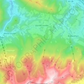
Name: Vorderstoder topographic map, elevation, terrain.
Location: Vorderstoder, Bezirk Kirchdorf, 4574, Austria (47.65021 14.18290 47.73973 14.27263)
Average elevation: 1,134 m
Minimum elevation: 508 m
Maximum elevation: 2,370 m
Other topographic maps
Click on a map to view its topography, its elevation and its terrain.
Großer Priel
Austria > Bezirk Kirchdorf > Hinterstoder
Großer Priel, Hinterstoder, Bezirk Kirchdorf, 4573, Austria
Average elevation: 1,919 m