
Thank you for supporting this site ❤️
Make a donation
Make a donation
Cherokee County topographic map
Click on the map to display elevation.
Thank you for supporting this site ❤️
Make a donation
Make a donation
About this map
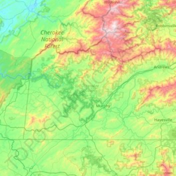
Name: Cherokee County topographic map, elevation, terrain.
Location: Cherokee County, North Carolina, United States (34.98707 -84.32183 35.29225 -83.69010)
Average elevation: 655 m
Minimum elevation: 253 m
Maximum elevation: 1,676 m
Thank you for supporting this site ❤️
Make a donation
Make a donation
Other topographic maps
Click on a map to view its topography, its elevation and its terrain.
Thank you for supporting this site ❤️
Make a donation
Make a donation
Cliffdale
United States > North Carolina > Cumberland County > Fayetteville > Cliffdale
Average elevation: 69 m