
Joy topographic map
Interactive map
Click on the map to display elevation.
About this map
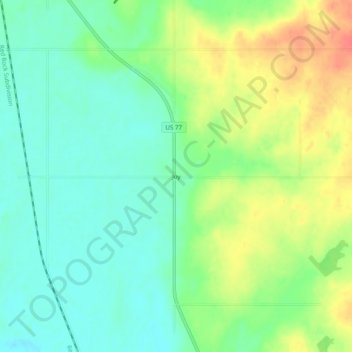
Name: Joy topographic map, elevation, terrain.
Location: Joy, Murray County, Oklahoma, United States (34.57370 -97.16224 34.61370 -97.12224)
Average elevation: 264 m
Minimum elevation: 244 m
Maximum elevation: 295 m
Other topographic maps
Click on a map to view its topography, its elevation and its terrain.
Davis
United States > Oklahoma > Murray County
Davis, Murray County, Oklahoma, United States
Average elevation: 276 m
Sulphur
United States > Oklahoma > Murray County
Sulphur, Murray County, Oklahoma, United States
Average elevation: 318 m