
Tokologo Ward 3 topographic map
Interactive map
Click on the map to display elevation.
About this map
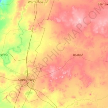
Name: Tokologo Ward 3 topographic map, elevation, terrain.
Average elevation: 1,214 m
Minimum elevation: 1,041 m
Maximum elevation: 1,422 m
Other topographic maps
Click on a map to view its topography, its elevation and its terrain.
Boshof
South Africa > Free State > Lejweleputswa District Municipality > Tokologo Local Municipality
Average elevation: 1,252 m
Hertzogville
South Africa > Free State > Lejweleputswa District Municipality > Tokologo Local Municipality
Average elevation: 1,285 m